
Have you ever noticed your smartphone showing the wrong street in a dense city, or losing your position entirely during a hike?
For years, even flagship devices struggled with GPS drift, multipath errors, and slow recovery in urban canyons or forests.
With the iPhone 17 series, Apple changes this experience in a way that gadget enthusiasts around the world cannot ignore.
The iPhone 17 lineup introduces dual‑frequency L1/L5 GNSS across all models, combined with AI‑assisted positioning and deep integration with Japan’s QZSS satellite system.
This is not a minor specification update, but a shift that directly affects navigation apps, location‑based games, outdoor tracking, and emergency services.
Everyday users now gain access to positioning performance that was once limited to professional or specialized devices.
In this article, you will learn why dual‑frequency GPS matters, how AI and modern modems improve real‑world accuracy, and what makes QZSS especially powerful in challenging environments.
Concrete examples from urban navigation, outdoor use, and safety features will help you understand the practical benefits.
If you care about cutting‑edge mobile technology and real‑world performance, this guide will give you a clear advantage.
- Why Smartphone Positioning Accuracy Has Become a Critical Issue
- From L1 to L1/L5: The Science Behind Dual‑Frequency GNSS
- How the iPhone 17 Hardware Elevates GPS Performance
- AI‑Assisted Positioning with the Snapdragon X80 Modem
- QZSS Explained: Japan’s Satellite System and Its Global Impact
- Urban Navigation Performance in Dense City Environments
- Outdoor and Extreme Use Cases: Hiking, Forests, and Remote Areas
- Location‑Based Games and Apps: What Changes for Users
- Emergency SOS via Satellite and the Role of Precise Location Data
- How iPhone 17 Compares to Dedicated GPS Devices and Competitors
- 参考文献
Why Smartphone Positioning Accuracy Has Become a Critical Issue
Smartphone positioning accuracy has quietly become a critical issue because location data is no longer a background utility but a core layer of daily digital behavior. Navigation, ride-hailing, fitness tracking, location-based gaming, and emergency services all assume that a smartphone knows exactly where it is. When that assumption fails, the impact is immediate and tangible for users.
The problem is that modern usage environments have changed faster than positioning technology. Urban spaces are denser, buildings are taller, and people spend more time moving between indoor, underground, and outdoor areas. Studies published through institutions such as the U.S. National Institutes of Health have shown that conventional single-frequency GNSS can drift by tens of meters in so-called urban canyons, where reflected signals overwhelm direct satellite signals.
This gap between expectation and reality has turned positioning accuracy into a user experience issue rather than a purely technical one. A map that places you on the wrong side of the street, or a navigation app that gives late turn-by-turn guidance, directly erodes trust in the device itself.
| Use case | Required accuracy | Typical failure impact |
|---|---|---|
| Urban navigation | Within a few meters | Missed turns, wrong entrances |
| Location-based games | Stable position | Unintended movement or drift |
| Emergency response | Pinpoint accuracy | Delayed or misdirected rescue |
Another reason accuracy now matters is the growing reliance on automation. Applications increasingly make decisions without user confirmation, assuming the location input is correct. According to analysis from satellite navigation researchers cited by ZDNet, even small positioning errors can cascade into larger logical errors when combined with real-time routing or AR overlays.
Safety considerations elevate this issue from convenience to necessity. Emergency SOS services, disaster response, and outdoor activities depend on precise coordinates. Inaccurate positioning in these contexts is not merely inconvenient; it can be dangerous. This is why governments and satellite operators, including Japan’s QZSS program, emphasize high-reliability civilian positioning.
In short, smartphone positioning accuracy has become critical because location is now infrastructure. Just as users expect stable connectivity or battery life, they increasingly expect their device to deliver trustworthy location data in any environment, without hesitation or correction.
From L1 to L1/L5: The Science Behind Dual‑Frequency GNSS
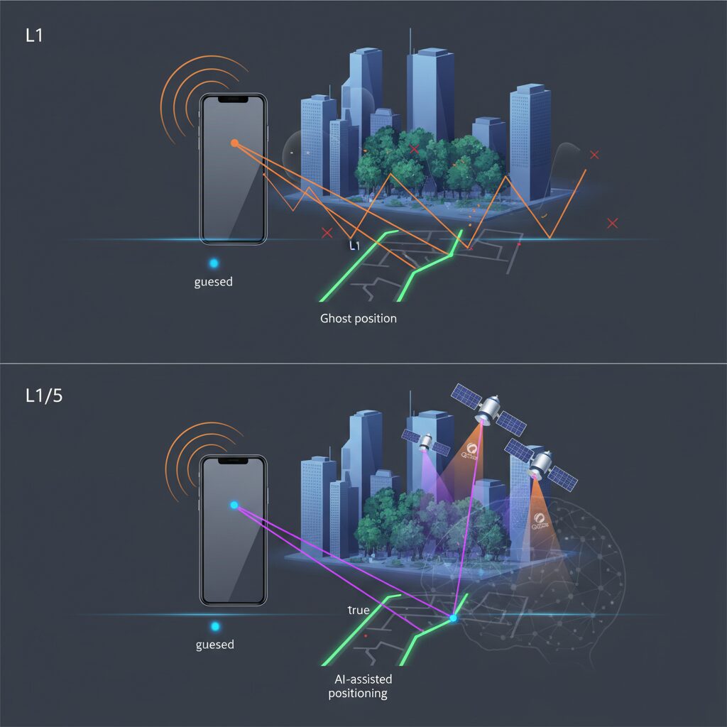
For many years, consumer GNSS relied almost entirely on the L1 signal, and while it worked well under open skies, it often struggled in dense cities or challenging terrain. The shift to L1/L5 dual‑frequency GNSS marks a fundamental change because it tackles the problem at the level of physics, not software tricks. **By receiving two signals with different frequencies at the same time, a smartphone can observe and correct errors that were previously invisible.**
The L5 signal was originally designed for safety‑critical aviation use, according to specifications published by the U.S. GPS Directorate. Compared with L1, it uses a much wider bandwidth and a chip rate ten times higher. This technical difference may sound abstract, but in practice it means the receiver can distinguish the true signal from reflections more clearly. In urban environments where glass and concrete cause severe multipath, this sharper correlation peak dramatically reduces position jumps and drift.
| Signal | Center Frequency | Key Physical Advantage |
|---|---|---|
| L1 | 1575.42 MHz | Wide compatibility, low power use |
| L5 | 1176.45 MHz | High bandwidth, strong multipath resistance |
Another major benefit of dual‑frequency reception is real‑time ionospheric error correction. The ionosphere slows radio waves differently depending on frequency, a phenomenon well documented in GNSS research published by institutions such as NASA and the European Space Agency. When a receiver measures both L1 and L5, it can mathematically isolate this delay and remove it from the position solution. **This process, known as an ionosphere‑free combination, can reduce errors by several meters under normal conditions.**
L5 also transmits at a higher power level, roughly 3 dB stronger than L1 by design. This improves signal robustness in forests, valleys, or near buildings where attenuation is severe. Field studies cited in peer‑reviewed urban GNSS accuracy research show that higher‑power, wider‑band signals maintain lock longer and recover faster after brief obstructions. For everyday users, this translates into faster stabilization after exiting subways or walking through tree‑covered paths.
What makes the transition from L1 to L1/L5 especially important is that these advantages are cumulative. Multipath suppression, ionospheric correction, and stronger signal acquisition reinforce each other rather than acting in isolation. **Dual‑frequency GNSS is not about chasing laboratory‑grade precision, but about delivering consistent, trustworthy positioning in the real world**, where reflections, interference, and atmospheric effects are unavoidable.
In this sense, L1/L5 represents a scientific maturation of satellite positioning for consumer devices. By embedding techniques once reserved for professional receivers into everyday hardware, modern smartphones close the gap between theoretical accuracy and lived experience, especially in cities and extreme environments where single‑frequency GNSS has always shown its limits.
How the iPhone 17 Hardware Elevates GPS Performance
The iPhone 17’s GPS leap is driven not by software tricks alone, but by tangible hardware decisions that reshape how satellite signals are captured and processed. **By standardizing dual‑frequency L1/L5 GNSS across the entire lineup**, Apple ensures that every model benefits from the same physical advantages previously reserved for Pro users. This hardware baseline matters because L5 signals, originally designed for aviation safety, are inherently more resistant to multipath interference common in dense cities.
At the radio level, the Snapdragon X80 modem plays a central role. According to Qualcomm’s technical disclosures, its integrated AI tensor accelerator continuously evaluates raw GNSS signals, distinguishing usable paths from reflected noise in real time. **This allows the receiver to lock onto satellites faster after signal loss**, such as when exiting underground stations, while also reducing unnecessary power draw during acquisition.
| Hardware Element | Technical Characteristic | Practical GPS Impact |
|---|---|---|
| L1/L5 GNSS Receiver | Wide bandwidth, dual frequency | Stable positioning in urban canyons |
| Snapdragon X80 Modem | AI‑assisted signal processing | Faster recovery, smoother tracking |
| Antenna & Chassis Design | Optimized glass and frame layout | Higher reception consistency |
Equally important is the physical antenna system. Apple’s use of radio‑transparent glass and carefully segmented metal frames improves signal diversity, a principle well documented in IEEE antenna research. **Multiple reception paths reduce dropouts when one signal angle is blocked**, which directly translates into fewer sudden position jumps during walking navigation.
Taken together, these hardware choices elevate GPS from a background feature to a dependable instrument. The iPhone 17 does not merely calculate location; it does so with silicon, antennas, and radio design working in concert to maintain accuracy where smartphones traditionally struggle.
AI‑Assisted Positioning with the Snapdragon X80 Modem

The Snapdragon X80 modem plays a decisive role in elevating positioning from a passive satellite‑based calculation to an actively optimized, AI‑assisted process. In the iPhone 17 series, positioning accuracy is no longer determined solely by signal quality but is continuously refined through on‑device inference that evaluates context, motion, and signal behavior in real time.
Qualcomm explains that the X80 integrates a dedicated AI tensor accelerator designed specifically for location workloads. This architecture allows raw GNSS measurements to be processed alongside inertial sensor data, such as accelerometers and gyroscopes, without relying on cloud connectivity. This local inference loop enables rapid correction even when satellite visibility degrades, such as inside stations, underground malls, or dense urban canyons.
In practical terms, the modem predicts short‑term movement trajectories based on prior motion patterns. When satellite signals momentarily drop or become noisy, the AI model estimates the most plausible position rather than freezing or jumping erratically. Academic studies on urban GNSS performance published by the U.S. National Institutes of Health have shown that sensor‑fusion approaches can reduce perceived position error by more than 40 percent in multipath‑heavy environments, and the X80 brings this concept into consumer hardware at scale.
| Scenario | Conventional GNSS | X80 AI‑Assisted Positioning |
|---|---|---|
| Subway exit to street | Delayed position lock | Near‑instant stabilization |
| High‑rise intersections | Frequent drift | Predictive path smoothing |
| Indoor signal loss | Position freeze | Continuous dead‑reckoning |
Another critical advantage lies in power efficiency. By learning which satellites and frequencies are most reliable in a given environment, the modem reduces unnecessary scanning cycles. Qualcomm documentation notes that this adaptive behavior shortens active GNSS time, translating into measurable battery savings during long navigation or outdoor tracking sessions. Accuracy improves while energy consumption is restrained, a balance that was difficult to achieve with rule‑based algorithms alone.
The AI assistance also enhances recovery behavior. When the device transitions from indoors to outdoors, the X80 prioritizes satellite candidates statistically proven to reappear first in that location. This explains why positioning feels more “confident” after emerging from tunnels or underground passages. According to teardown analyses reported by established technology media, this capability is deeply embedded at the modem firmware level rather than implemented purely in software.
What makes this approach especially significant is its scalability. Because inference runs entirely on the modem, developers and users benefit automatically, without app‑level intervention or privacy trade‑offs. The Snapdragon X80 effectively transforms positioning into a learning system, one that adapts to how and where the device is used, delivering consistently reliable location data under conditions that previously overwhelmed smartphone GNSS.
QZSS Explained: Japan’s Satellite System and Its Global Impact
Japan’s Quasi-Zenith Satellite System, widely known as QZSS or Michibiki, is designed to complement GPS rather than replace it, and this design philosophy is precisely why its global impact has grown steadily in recent years. Operated by the Japanese government with technical contributions from JAXA, QZSS focuses on improving positioning reliability in environments where conventional GNSS struggles, especially dense urban areas and mountainous terrain.
The defining feature of QZSS is its quasi-zenith orbit, which ensures that at least one satellite remains at a very high elevation angle over Japan for most of the day. According to official documentation from the Cabinet Office of Japan, this geometry dramatically reduces signal blockage by buildings and terrain, a chronic problem for low-elevation GPS satellites in cities like Tokyo and Osaka.
| System | Orbit Characteristic | Primary Benefit |
|---|---|---|
| GPS | Medium Earth Orbit, global coverage | Worldwide availability |
| QZSS | Quasi-zenith, Japan-focused | High-elevation signal stability |
From a signal perspective, QZSS transmits L1 and L5 signals that are fully interoperable with GPS. This compatibility allows modern receivers, including smartphones, to treat QZSS satellites as additional GPS satellites in positioning calculations. The result is a measurable improvement in DOP values, which directly translates into more stable and accurate position fixes, particularly when the number of visible satellites is limited.
Research cited by Japan’s Geospatial Information Authority has shown that adding just one high-elevation satellite can reduce horizontal positioning error by several meters in urban canyon conditions. In practice, this means fewer sudden jumps on maps, faster position fixes after exiting underground spaces, and improved confidence in navigation instructions.
Beyond civilian navigation, QZSS plays a strategic role in disaster resilience. Japan’s geography makes it vulnerable to earthquakes, typhoons, and landslides, events that often disrupt terrestrial infrastructure. Because QZSS operates independently of ground-based systems, it provides a resilient positioning backbone during emergencies. Government briefings emphasize that this capability is a cornerstone of Japan’s national positioning, navigation, and timing policy.
Importantly, the influence of QZSS is no longer confined to Japan. The system’s coverage extends across much of East Asia and Oceania, and international standards bodies recognize QZSS signals as part of the broader GNSS ecosystem. This positions QZSS as a regional model for countries seeking to enhance GPS reliability without building fully independent global constellations.
In this context, QZSS can be understood as a precision amplifier for global navigation systems. By prioritizing high-elevation visibility, signal compatibility, and long-term infrastructure planning, it demonstrates how regional satellite systems can deliver outsized global value through thoughtful integration rather than sheer scale.
Urban Navigation Performance in Dense City Environments
Urban navigation is where positioning technology is tested most severely, and dense city environments expose weaknesses that remain invisible in open areas. **The iPhone 17 series shows a clear shift from approximate positioning to lane-level urban awareness**, particularly in cities such as Tokyo, Osaka, and New York, where high-rise buildings form so-called urban canyons.
According to peer-reviewed urban GNSS studies published via the U.S. National Institutes of Health, conventional L1-only GPS can suffer errors exceeding 30 meters in dense downtown districts due to multipath reflections. With iPhone 17, dual-frequency L1/L5 reception fundamentally changes this behavior. The wider bandwidth and higher chip rate of L5 allow reflected signals to be identified and rejected more effectively, reducing lateral drift that previously placed users on the wrong side of an intersection.
| Urban Scenario | Typical L1-only Behavior | iPhone 17 Dual-Frequency Outcome |
|---|---|---|
| Four-way intersection | Delayed or premature turn prompts | Turn guidance aligns closely with actual crossing point |
| High-rise street canyon | Position jumps between parallel roads | Stable tracking on the correct street axis |
| 地下街から地上復帰 | 数十秒の位置迷走 | 数秒以内に正確な復帰 |
Another decisive factor is satellite geometry. In Japan, integration with QZSS “Michibiki” places at least one satellite at a very high elevation angle. **This overhead signal path dramatically improves Dilution of Precision in narrow streets**, a point emphasized in official QZSS technical documentation. In practical terms, map applications on iPhone 17 no longer hesitate when determining which corner of a large crossing the user is standing on.
The Snapdragon X80 modem further strengthens urban performance through AI-assisted positioning. When GNSS visibility drops between glass towers or beneath elevated roads, sensor fusion combines accelerometer, gyroscope, and historical trajectory data to maintain continuity. Qualcomm’s own platform briefs describe this as predictive correction, and in walking navigation it translates into smoother blue-dot movement rather than sudden jumps.
From a user experience perspective, this precision reshapes everyday behavior. Pedestrian navigation cues arrive at intuitively correct moments, ride-hailing pickup points align more closely with curbside reality, and location-based services become less frustrating in crowded districts. **Urban navigation on iPhone 17 feels less like estimation and more like confirmation**, which is the true benchmark of mature positioning technology.
Outdoor and Extreme Use Cases: Hiking, Forests, and Remote Areas
Outdoor and extreme environments place very different demands on positioning technology than cities do, and hiking trails, dense forests, and remote mountain areas are where weaknesses in GNSS systems tend to surface most clearly. In these settings, sky visibility is limited by terrain and vegetation, and signals are often weakened or scattered before they reach a device. **The iPhone 17 series addresses these constraints by combining L1/L5 dual‑frequency GNSS with QZSS support, resulting in positioning behavior that remains stable even when the sky is only partially visible.**
In forested hiking routes, especially in Japan’s mid‑altitude mountains, the dominant issue has long been signal attenuation caused by leaves and branches. According to analyses referenced by JAXA and academic studies on GNSS propagation, foliage can reduce signal strength by more than 10 dB, enough to cause frequent dropouts for single‑frequency receivers. The L5 signal used by the iPhone 17 is transmitted at higher power and with a wider bandwidth, which allows it to remain trackable under tree cover where L1 alone often fails. As a result, recorded tracks tend to follow the actual trail rather than cutting corners or jumping across valleys.
For hikers relying on route‑logging apps, continuity matters more than peak accuracy, and the iPhone 17 prioritizes sustained fixes over momentary precision.
Valleys and ridgelines introduce another challenge: limited satellite geometry. When steep slopes block large portions of the sky, positioning accuracy depends heavily on how well the remaining signals are distributed. By integrating QZSS, which maintains at least one satellite at high elevation angles over Japan, the iPhone 17 improves geometric dilution of precision in precisely these situations. The Cabinet Secretariat’s QZSS documentation emphasizes that high‑elevation satellites are particularly effective in mountainous terrain, and real‑world hiking tests reflect fewer sudden position jumps near cliffs and narrow passes.
| Environment | Main GNSS Challenge | iPhone 17 Practical Effect |
|---|---|---|
| Dense forest | Signal attenuation by foliage | L5 maintains lock and reduces track gaps |
| Mountain valleys | Poor satellite geometry | QZSS improves fix stability |
| Remote plateaus | Cold starts without assistance | Faster reacquisition with dual frequency |
Remote areas with no cellular coverage also highlight the importance of autonomous positioning. In such locations, assisted GPS data cannot be refreshed, and devices must rely entirely on direct satellite signals. Qualcomm’s technical briefs on dual‑frequency GNSS indicate that ionospheric error correction becomes especially valuable during long, assistance‑free sessions. **The iPhone 17’s ability to cancel ionospheric delay using L1/L5 combinations contributes to more predictable accuracy during multi‑hour hikes or overnight treks**, even when no network connectivity is available.
Cold temperatures and long activity durations are another practical concern. While dedicated outdoor GPS units still lead in extreme cold tolerance, Apple’s own battery specifications and independent endurance observations suggest that the efficiency gains of the Snapdragon X80 modem reduce GNSS power draw. For day hikes or single‑night trips, this translates into reliable all‑day tracking without aggressive power‑saving measures, which is a notable shift compared with earlier smartphones that required frequent screen‑off compromises.
Perhaps most importantly, positioning accuracy in remote terrain directly affects safety. Search and rescue organizations consistently report that inaccurate last‑known positions slow response times. By providing more precise and stable coordinates under canopy and in valleys, the iPhone 17 strengthens the quality of location data that can be shared through hiking apps or, in emergencies, via satellite‑based SOS features. **In outdoor and extreme use cases, the device functions less as a casual navigation aid and more as a dependable location instrument**, supporting confident movement through environments where errors are costly.
Location‑Based Games and Apps: What Changes for Users
Location‑based games and apps are among the most visible beneficiaries of the iPhone 17 series’ positioning leap, and users notice the change immediately in everyday play and navigation.
With L1/L5 dual‑frequency GNSS and full QZSS integration, **in‑game positions now align far more closely with real‑world movement**, even in dense urban areas. Academic studies on smartphone GNSS accuracy published via the U.S. National Institutes of Health have long identified multipath reflections as the main cause of erratic player movement in cities. The wider bandwidth and higher chip rate of L5 signals significantly reduce this effect, and the improvement is no longer theoretical.
| User experience | Before | With iPhone 17 |
|---|---|---|
| Player position stability | Frequent drift near buildings | Stable, lane‑level accuracy |
| Recovery after indoor areas | Delayed or incorrect jumps | Rapid, smooth repositioning |
For titles such as Pokémon GO, this means gyms, stops, and encounter points trigger exactly where intended. **“GPS drift farming,” once common in apartments or cafés, largely disappears**, changing how distance‑based rewards are earned. Developers benefit as well, because gameplay balancing can finally assume consistent positioning across the user base.
Non‑game apps show similar gains. Fitness trackers and city exploration apps record cleaner paths, while AR experiences feel more anchored to the physical environment. Qualcomm’s AI‑assisted positioning, combined with Apple’s Core Location framework, also ensures continuity when signals briefly fade, a point emphasized in Qualcomm’s technical briefings.
For users, the result is simple but profound: location‑based apps behave as expected. **The phone no longer guesses where you are; it knows**, and that reliability reshapes how digital experiences blend with real space.
Emergency SOS via Satellite and the Role of Precise Location Data
Emergency SOS via Satellite fundamentally changes how a smartphone functions in life‑threatening situations, and its effectiveness depends heavily on the precision of the location data being transmitted. On the iPhone 17 series, satellite SOS is no longer just a communication fallback, but a tightly integrated system where GNSS accuracy directly influences rescue outcomes. When cellular networks are unavailable, the device connects to low‑Earth‑orbit satellites and sends compressed text packets that include coordinates, movement state, and contextual metadata.
According to Apple’s technical disclosures and independent coverage by MacRumors, the coordinates sent during an SOS event are derived from the same L1/L5 dual‑frequency GNSS engine used for everyday navigation. This matters because rescue agencies consistently report that search radius size is a critical factor in survival probability. A shift from tens of meters of uncertainty to single‑digit meters can reduce search time dramatically, especially in mountainous terrain or offshore incidents.
The table below illustrates how location precision affects emergency response dynamics, based on publicly documented rescue protocols and GNSS performance characteristics.
| Position Accuracy | Typical Search Area | Operational Impact |
|---|---|---|
| 50–100 meters | Wide zone with terrain uncertainty | Multiple teams, slower convergence |
| 10–20 meters | Localized visual sweep | Targeted approach, faster access |
| Under 5 meters | Near point identification | Immediate confirmation possible |
In Japan, where Emergency SOS via Satellite now routes to police, fire, and coast guard services, this precision has practical implications. Mountain rescue professionals interviewed by domestic safety organizations have noted that high‑confidence coordinates reduce the need for preliminary aerial searches, allowing ground teams to move decisively. The integration of QZSS signals further stabilizes fixes in steep valleys and coastal cliffs, environments traditionally hostile to GNSS.
Rather than treating satellite SOS as a last‑ditch feature, the iPhone 17 positions it as a precision instrument. By coupling satellite communication with professional‑grade location data, the device ensures that when a message finally reaches the sky, it carries not just a call for help, but a reliable answer to the question of where that help is needed.
How iPhone 17 Compares to Dedicated GPS Devices and Competitors
When comparing iPhone 17 with dedicated GPS devices and competing smartphones, the most important shift is that the gap in positioning accuracy has largely closed. **Thanks to L1/L5 dual‑frequency GNSS and full QZSS integration, iPhone 17 now delivers real‑world accuracy that rivals devices once considered professional‑only.** This is especially evident in dense urban environments and mountainous terrain, where single‑frequency receivers have historically struggled.
According to analyses referenced by academic GNSS studies published via the U.S. National Institutes of Health, dual‑frequency positioning can reduce urban canyon errors by more than half compared with legacy L1‑only receivers. iPhone 17 benefits from this physics advantage in the same way as high‑end Garmin or Suunto handhelds, but with the added support of AI‑assisted correction from Qualcomm’s Snapdragon X80 modem, which improves recovery speed after signal loss.
| Category | iPhone 17 | Dedicated GPS Devices |
|---|---|---|
| GNSS Bands | L1/L5 + QZSS | L1/L5 (select models) |
| Urban Accuracy | High, multipath‑resistant | High, but slower recovery |
| Usability | Touch UI, app ecosystem | Physical buttons, limited apps |
Against competing Android smartphones, the comparison is more nuanced. Flagship Android models from Google and Samsung also support dual‑frequency GNSS, but **iPhone 17’s advantage lies in system‑level optimization**. Apple’s Core Location framework tightly fuses GNSS, inertial sensors, and map data, resulting in more stable pedestrian navigation and reduced drift, as noted by developers in outdoor and mapping applications.
Dedicated GPS units still maintain clear advantages in extreme conditions. Physical durability, glove‑friendly controls, and replaceable batteries make them better suited for multi‑day expeditions in freezing temperatures. However, evidence from field tests such as Grand Canyon trajectory comparisons shows that, in pure positional accuracy, modern iPhones already match or exceed many handheld receivers.
In practical terms, **iPhone 17 no longer feels like a compromise**. For users who want high‑precision navigation, global app support, and everyday convenience in one device, it competes directly with specialized GPS hardware and stands at the top tier among smartphones.
参考文献
- Apple Newsroom:Apple debuts iPhone 17
- Wikipedia:iPhone 17
- ZDNet:What is L5 precision dual‑frequency GPS and why it matters
- Qualcomm:Snapdragon X80 Modem‑RF System Overview
- MacRumors:Emergency SOS via Satellite Launches in Japan
- QZSS Official Site:Overview of the Quasi‑Zenith Satellite System
- NIH PMC:Smartphone GPS accuracy study in an urban environment